Dr. Kerem Halicioglu - The Earth’s gravity field through star images: Digital Zenith Camera Systems
Abstract
Geoid, as a special gravitational equipotential surface, is considered as a datum for both engineering and geodetic studies. The gravity field of the Earth can be modeled in local and global scales through using several geodetic techniques such as gravimetry, GNSS/Levelling, Chronometric levelling, and astro-geodetic method. In addition, Geodetic astronomy is the only technique that provides direct observations of the plumb line, and provides independent data for better understanding the Earth’s gravity field.
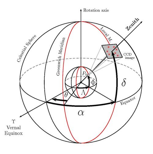
The objective of the astro-geodesy is to determine astronomical coordinates at observation points on the Earth’s surface using direction measurements to celestial bodies, such as reference stars. Astronomical coordinates (Φ,Λ) define the orientation of local gravity vector in space, hence the direction of the local plumb line (represented by deflection of the vertical components - DoV). DoV components can be obtained by a specially designed instrument called Digital Zenith Camera Systems (DZCS). DZCS are being used in several European countries for the geoid determination. Since 2015 the first DZCS of Turkey is operational, and currently it is being modernized for further research and higher accuracy. The system has been successfully tested and used in Istanbul and the results were compared with local and global models (i.e. global gravitational models). Yet the accuracy of the system not only depends on the sensor sensitivity, but is also highly related to the processing of the star images. Therefore, there is a necessity to develop more precise and alternative image processing methods for the astro-geodetic observations.
Leaning on this background this presentation includes three main parts: The first part will describe the instrumental design and observables of geodetic astronomy in Turkey, and the DZCS observations. The second part will focus on modelling the star trails to investigate the maximum achievable accuracy, using synthetic and real observation data. The final part will discuss the relationship of the ground and space based geodetic techniques through the processing of satellite imagery.
Biography
Dr. Kerem Halicioglu completed his PhD in the field of geodetic astronomy at Istanbul Technical University in Turkey. His PhD research titled “Determination of Astro-geodetic deflection of the vertical using Digital Zenith Camera System”, and during his research he developed and tested the first digital zenith camera system of Turkey to observe the direction of the gravity vector. He worked as a researcher at Bogazici University between 2005-2017, and specialized on GNSS data processing and on deformation analysis using ground based observations and satellite data. Since July 2018 he continues his studies as an Einstein Junior Scholar at Freie Universität Berlin in the Mathematical Geometry Processing working group.
Time & Location
Sep 27, 2018 | 03:00 PM
FU Berlin | Arnimallee 6 | Raum 108/109

